
 By
At 3:42 p.m. Eastern on Friday, a Porter Airlines flight took off from Ottawa and headed south. A minute later an Air Canada Express flight left Toronto's Billy Bishop airport, also bound across the border.
Four minutes earlier, departures across the United States had stopped. Twelve minutes later, the US Federal Aviation Administration put that stop in writing: every airport in the country was ground stopped "for reasons of safety."
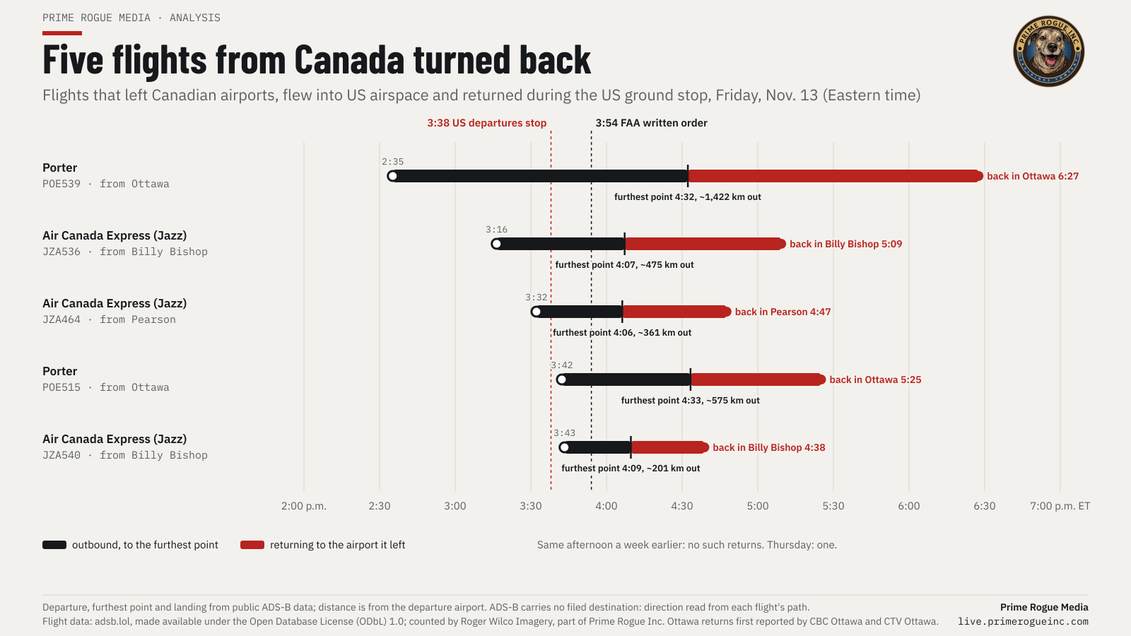
Neither flight landed in the US. Both turned around and landed where they had started. So did three others that had left Canada earlier that afternoon. One, a Porter flight out of Ottawa, had been in the air for almost two hours and was over South Carolina, about 1,400 km from Ottawa, when it turned back.
CBC Ottawa and CTV Ottawa reported on Friday evening that two flights from Ottawa had returned mid-flight. Public flight-tracking data, counted flight by flight by Prime Rogue's Roger Wilco Imagery, now identifies them and shows three more, all to Toronto. It also shows how completely the stop cut Canada off from the US: no airline flight that left Canada after 3:33 p.m. reached one of the 100 busiest US airports until one that took off at 9:19 p.m.
The five flights
Every aircraft in this story broadcast its own position, by ADS-B, several times a minute. The adsb.lol archive keeps those reports. We mapped every report for each flight; nothing is smoothed or filled in.
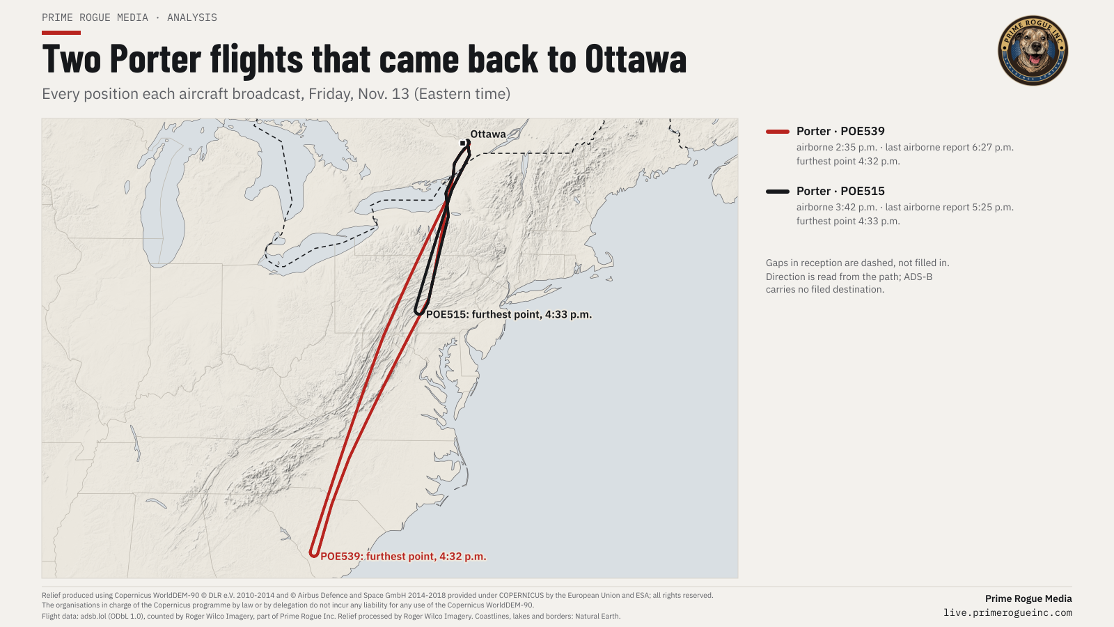
- Porter POE539 left Ottawa at 2:35 p.m. and flew south along the Appalachians. Its furthest point came at 4:32 p.m., over South Carolina, about 1,400 km from Ottawa. It then flew back the way it came and landed in Ottawa at 6:27 p.m., nearly four hours after take-off.
- Porter POE515 left Ottawa at 3:42 p.m., four minutes after US departures had stopped. It crossed into US airspace within a couple of minutes of the FAA's written order. It got as far as central Pennsylvania, west of Harrisburg, at 4:33 p.m., 51 minutes after take-off, and landed back in Ottawa at 5:25 p.m.
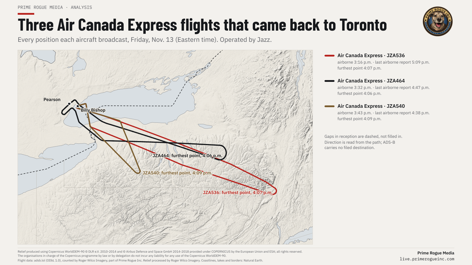
- Air Canada Express JZA536, operated by Jazz, left Billy Bishop at 3:16 p.m. It reached New York's Hudson Valley at 4:07 p.m. and was back at Billy Bishop at 5:09 p.m.
- Air Canada Express JZA464 left Toronto Pearson at 3:32 p.m., reached central New York at 4:06 p.m. and was back at Pearson at 4:47 p.m.
- Air Canada Express JZA540 left Billy Bishop at 3:43 p.m., five minutes after US departures had stopped. It reached western New York at 4:09 p.m. and was back at Billy Bishop at 4:38 p.m.
The three Air Canada Express flights turned within three minutes of each other, between 4:06 and 4:09 p.m. That was 12 to 15 minutes after the FAA's written order.
Passengers told CBC their Ottawa flight to Fort Lauderdale turned around about 45 minutes into the trip. Porter has since confirmed that POE515 (its flight PD515) was bound for Fort Lauderdale, and POE539 (PD539) for Fort Myers. ADS-B does not carry a flight's destination, so for the three Jazz flights we read where each was heading from its path. We have asked Jazz and Air Canada to confirm those destinations, and all three airlines who told each flight to return. Updated Nov. 16 with Porter's reply.
On the same Friday afternoon a week earlier, we found no flights like these. On Thursday, the day before the stop, we found one.
The door closed at 3:33
The FAA's order covered departures from US airports. Flights to the US from abroad, it said, would be "managed on a case by case basis." In practice, almost nothing from Canada got in, and the data cannot show who decided that: the FAA, NAV CANADA or the airlines themselves.
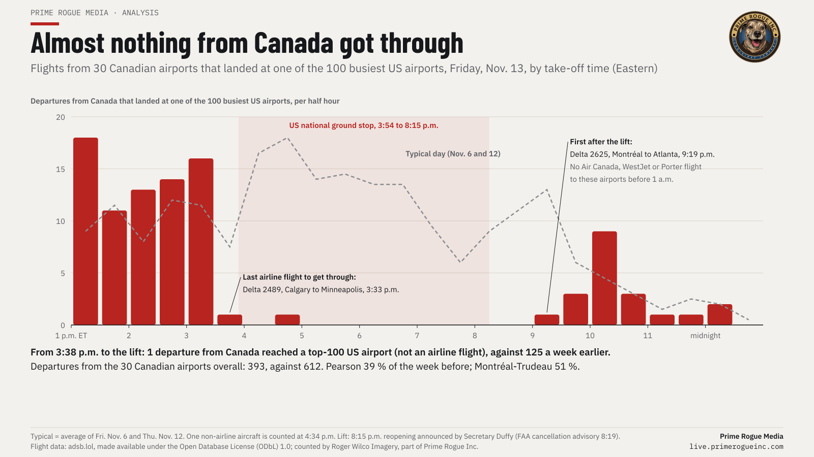
The last airline flight from a Canadian airport to reach one of the 100 busiest US airports before the halt was Delta 2489, which left Calgary for Minneapolis at 3:33 p.m. ET.
From 3:38 p.m. until 8:15 p.m., when Transportation Secretary Sean Duffy announced the reopening (the FAA's written cancellation followed at 8:19), the 30 Canadian airports we track had 393 departures, against 612 in the same hours a week earlier. Of those, flights that went on to land at one of the 100 busiest US airports: one, and it was not an airline flight. A week earlier there were 125. Pearson's departures ran at 39 per cent of the week before. Montréal-Trudeau's ran at 51 per cent.
Canada's airlines did not go back after the lift. Air Canada, WestJet and Porter flew no flights to those US airports again before 1 a.m. Air Canada had said on X, according to The Globe and Mail's live coverage, that it was cancelling its US flights "for the remainder of the evening." The first flight from Canada to reach a major US airport after the lift was Delta 2625, which left Montréal for Atlanta at 9:19 p.m.
Toronto and Chicago
The first trouble in the FAA's record was in Chicago, and Toronto's flights were caught in it.
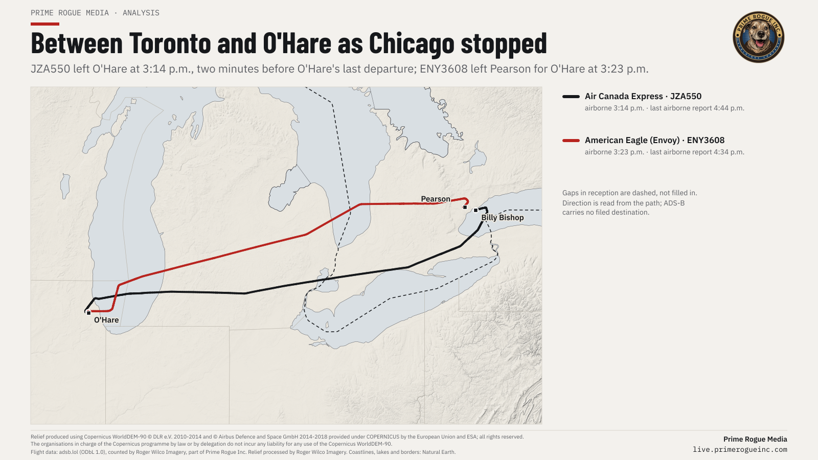
At 3:14 p.m. an Air Canada Express flight, JZA550, left O'Hare for Billy Bishop. It was the second-last flight to leave O'Hare before the national stop; the last, a Japan Airlines flight, left at 3:16. Nothing else took off from O'Hare until 7:03 p.m.
At 3:23 p.m., ENY3608, an American Eagle flight operated by Envoy, left Pearson for O'Hare. The FAA's advisory for its O'Hare ground stop, which lists Pearson among the airports whose flights to O'Hare were held, dates the stop from 3:10 p.m. But the same advisory gives its own effective time as 3:27 p.m. The Pearson flight left in between, and landed at O'Hare at 4:34 p.m. ABC7 Chicago and FOX 32 reported the O'Hare and Midway stop times on Friday.
A flight that landed in Montréal
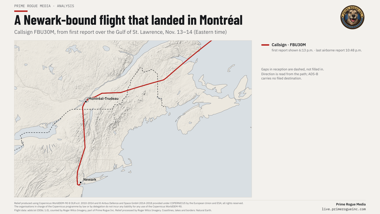
One overseas flight, callsign FBU30M, which lands at Newark on other days in our data, came in over the Gulf of St. Lawrence and landed at Montréal-Trudeau at 7:34 p.m. It stayed on the ground for about two hours and 17 minutes, then left for Newark at 9:51 p.m. NAV CANADA told The Globe and Mail on Friday that some flights were diverted to Canada, without giving details. This is the only one our data identifies.
Canada's own ground stops
While all this was happening, NAV CANADA, which runs Canada's air traffic control, put its own ground stops on flights bound for Canada's two busiest airports. Its advisories, published on the FAA's site, held flights for Pearson from 4:54 to 6:05 p.m. and for Montréal-Trudeau from 5:00 to 6:03 p.m. The condition given was "OTHER / OTHER." NAV CANADA publicly described "traffic management measures" at Pearson, Montréal-Trudeau, Calgary and Vancouver. We have asked what the "other" condition was, and whether the stops were connected to returning or diverted flights.
By 5:04 p.m., Toronto Pearson's website was telling travellers there were "no scheduled U.S.-bound departures or arrivals at this time."
What we asked
We sent requests on Sunday morning, with a deadline of noon ET on Monday, November 16, to:
- Porter, Jazz and Air Canada: where the five flights were going, who instructed each to return, and why two were dispatched after US departures had stopped.
- The FAA: who held O'Hare's departures from 3:16 p.m., and when the O'Hare stop actually took effect for departing airports.
- Ottawa, Billy Bishop, Pearson and Montréal-Trudeau airports: when and from whom they learned of the stop, and what returned or diverted to them.
- NAV CANADA: what lay behind the "other" condition on its ground stops, and how many flights diverted into Canada.
- Transport Canada: whether it, or anyone in the federal government, told Canadian airlines that US departures had stopped, and whose job that is.
- Public Safety Canada: whether the Government Operations Centre knew of the returns or diversions.
- The Canada Border Services Agency: how many international flights diverted into Canada, and what happened to their passengers.
Replies so far (updated Nov. 16): Porter Airlines said PD539 "was headed to Fort Myers" and PD515 "was headed to Fort Lauderdale," and that both "were turned around due to the airspace closure." It said it was "unable to provide any more details." Porter did not say who instructed the flights to return or why PD515 was dispatched at 3:42 p.m. Public Safety Canada said the federal Government Operations Centre knew there had been diversions but named none in its products, and referred us to Transport Canada, which had not replied by the time of this update.
We will add their answers here.
How we did this
The flight data comes from adsb.lol's public archive of ADS-B reports, made available under the Open Database License, as collected by a volunteer network of receivers. Roger Wilco Imagery, part of Prime Rogue Inc., counted departures and arrivals at 100 US and 30 Canadian airports for November 13, against November 6 and November 12, and exported every position report for the flights named here. A departure is an aircraft's first airborne position near a listed airport, followed by a climb. Times are take-off and landing, not gate times.
Limits: the network does not hear every aircraft everywhere; military and some private aircraft are missing; and ADS-B carries no filed destination. Our counts are of aircraft heard, and are not comparable with FlightAware's, Cirium's or the FAA's figures. "Furthest point" is the point on each track furthest from the departure airport. Place descriptions are our reading of the coordinates.
A second pass across 372 Canadian airports, including every airport with scheduled service, found no other flight from Canada that turned back from the US and no other diversion into Canada. Remote airfields are not always within range of a receiver.
The maps use relief from the Copernicus DEM, processed by Roger Wilco Imagery and exaggerated vertically so it reads at this scale, and coastlines, lakes and borders from Natural Earth. The FAA and NAV CANADA advisories were retrieved verbatim from fly.faa.gov. Every file is archived with a checksum.
Flight data: adsb.lol, made available under the Open Database License (ODbL) 1.0; counted by Roger Wilco Imagery, part of Prime Rogue Inc. Relief produced using Copernicus WorldDEM-90 © DLR e.V. 2010-2014 and © Airbus Defence and Space GmbH 2014-2018 provided under COPERNICUS by the European Union and ESA; all rights reserved. The organisations in charge of the Copernicus programme by law or by delegation do not incur any liability for any use of the Copernicus WorldDEM-90.
Roger Wilco Imagery is part of Prime Rogue Inc., which publishes Prime Rogue Media. Its counts are automated and LLM-assisted, and were checked against the raw files by the reporter's team.